North Dakota Scenic Byways: 8 Drives That Showcase Natural Beauty
When most people think of scenic road trips, North Dakota might not immediately come to mind. Yet this hidden gem of the Great Plains offers some of the most breathtaking and diverse landscapes in the American Midwest. From the rugged badlands in the west to the pristine lakes and prairies in the east, North Dakota’s scenic byways tell the story of a land shaped by ancient seas, glacial movements, and the endless dance between earth and sky.
These carefully designated routes aren’t just roads – they’re gateways to understanding the raw beauty and rich history that define the Peace Garden State. Whether you’re a photography enthusiast chasing the perfect sunset, a history buff exploring Lewis and Clark’s footsteps, or simply someone seeking solitude among wide-open spaces, North Dakota’s scenic byways offer experiences that will surprise and captivate you.
The Enchanted Highway: A Journey Through Art and Prairie
Stretching 32 miles along Highway 21 from Gladstone to Regent, the Enchanted Highway transforms an ordinary drive into an extraordinary outdoor art gallery. This unique byway features the world’s largest collection of scrap metal sculptures, each one towering against the endless prairie sky like monuments to human creativity and imagination.
The journey begins with “Geese in Flight,” a 110-foot-tall sculpture that appears to soar above the grasslands. As you continue south, you’ll encounter “Deer Crossing,” “Grasshoppers in the Field,” and the crown jewel – “World’s Largest Tin Family,” standing 45 feet tall. Created by local artist Gary Greff, these sculptures were designed to draw visitors to this remote corner of North Dakota, and they succeed brilliantly.
What makes this drive particularly special is how the art complements rather than competes with the natural landscape. The rolling hills, native grasslands, and big sky country provide the perfect backdrop for these whimsical creations. Plan to spend at least half a day here, allowing time to photograph each sculpture and appreciate the craftsmanship that went into their creation.
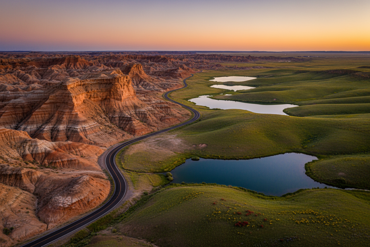
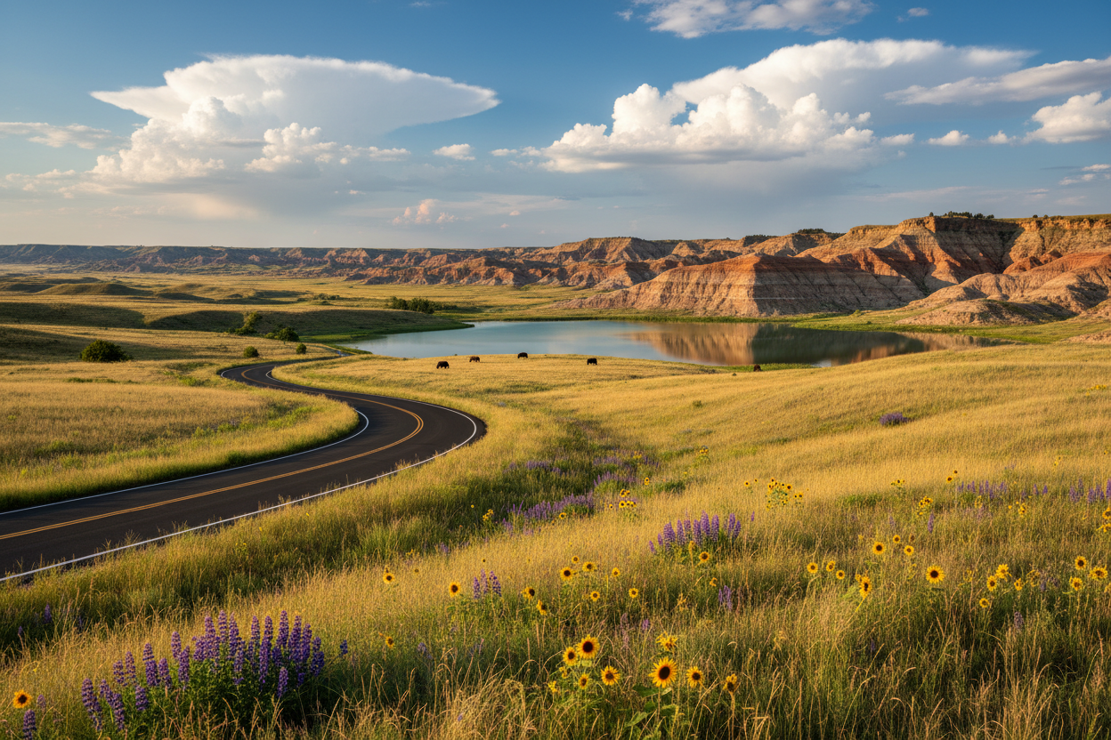
Maah Daah Hey Trail Scenic Byway: Into the Heart of the Badlands
The Maah Daah Hey Trail Scenic Byway follows portions of Highway 85 and various county roads through the spectacular badlands of western North Dakota. This 144-mile route connects Theodore Roosevelt National Park’s three units while showcasing some of the most dramatic terrain in the northern Great Plains.
The name “Maah Daah Hey” comes from the Mandan language, meaning “an area that has been or will be around for a long time.” It’s a fitting description for this ancient landscape of colorful sedimentary rock formations, carved buttes, and deep canyons that have been millions of years in the making.
As you drive this route, you’ll witness the same rugged beauty that captivated Theodore Roosevelt and inspired his conservation philosophy. The Little Missouri River winds through the badlands like a green ribbon, creating oases of cottonwoods and wildlife habitat. Keep your eyes peeled for wild horses, bison, elk, and prairie dogs – the same animals that Roosevelt hunted and studied during his time as a rancher here.
The byway offers numerous overlooks and hiking opportunities, including access to the famous Painted Canyon and the Maltese Cross Cabin where Roosevelt once lived. Each viewpoint reveals new layers of geological history written in stone and sediment.
Sheyenne River Valley Scenic Byway: Following Ancient Waters
The Sheyenne River Valley Scenic Byway traces 63 miles of Highway 46 through one of North Dakota’s most ecologically diverse regions. This route follows the meandering Sheyenne River through a landscape that transitions from prairie pothole country to hardwood forest, creating a corridor of remarkable biodiversity.
What makes this byway unique is its geological story. The Sheyenne River valley was carved by glacial meltwater thousands of years ago, creating a deep channel that now supports an ecosystem unlike anywhere else in North Dakota. The river’s oxbows and backwaters provide critical habitat for waterfowl, while the surrounding hills are covered with oak, ash, and maple trees that explode with color each autumn.
The town of Valley City, known as the “City of Bridges,” serves as the byway’s centerpiece. Here, the Hi-Line Railroad Bridge soars 162 feet above the Sheyenne River, offering spectacular views of the valley below. The nearby Baldhill Dam creates a popular recreation area where you can fish, boat, or simply enjoy a picnic while watching pelicans and eagles soar overhead.
For nature enthusiasts, the Sheyenne National Grassland provides opportunities to explore native prairie and observe grassland birds like bobolinks and sedge wrens that are becoming increasingly rare elsewhere.
Sakakawea Trail: Exploring Lewis and Clark’s Route
The Sakakawea Trail follows Highway 200 for approximately 420 miles across central North Dakota, tracing much of the route taken by the Lewis and Clark Expedition in 1804-1806. Named after Sacagawea, the Shoshone woman who guided the expedition, this byway combines historical significance with stunning natural beauty.
The trail passes through diverse landscapes, from the Missouri River breaks to rolling prairie hills dotted with wetlands. Lake Sakakawea, one of the largest man-made lakes in the United States, dominates much of the route, offering endless opportunities for water recreation and wildlife viewing.
Historical markers along the way tell the story of the expedition’s encounters with Native American tribes, their struggles with harsh weather, and their amazement at the abundant wildlife. At Fort Mandan, near present-day Washburn, you can visit a replica of the fort where the expedition spent the winter of 1804-1805 and where Sacagawea gave birth to her son.
The byway also showcases North Dakota’s agricultural heritage, passing through fields of wheat, corn, and sunflowers that stretch to the horizon. Small farming communities along the route offer glimpses into rural life and hospitality that remains largely unchanged from earlier generations.
Native American Scenic Byway: Honoring Indigenous Heritage
The Native American Scenic Byway encompasses several routes totaling about 330 miles through the heart of North Dakota’s Native American reservations. This culturally significant journey passes through the Fort Berthold, Spirit Lake, Standing Rock, and Turtle Mountain reservations, offering visitors the opportunity to learn about the rich heritage and contemporary life of North Dakota’s indigenous peoples.
The landscape along this byway is as diverse as the cultures it represents. From the rolling hills of the Turtle Mountains to the expansive waters of Devils Lake, each section offers unique natural beauty. The Missouri River corridor provides dramatic bluffs and bottomlands that have supported human habitation for thousands of years.
Cultural centers, museums, and interpretive sites along the route provide insights into traditional ways of life, contemporary Native American art, and the ongoing efforts to preserve indigenous languages and customs. The Three Affiliated Tribes Museum at New Town and the Four Winds Lodge at Devils Lake are particularly noteworthy stops.
Wildlife viewing opportunities abound, especially around Devils Lake, where you might spot white pelicans, trumpeter swans, and dozens of other bird species. The area’s wetlands and grasslands support one of North America’s most important waterfowl breeding areas.
Grand Forks to Devils Lake Scenic Route: Prairie Pothole Paradise
This unofficial but spectacular 150-mile route connects Grand Forks to Devils Lake via Highway 2, passing through the heart of North Dakota’s prairie pothole region. Often called the “duck factory of North America,” this landscape was shaped by retreating glaciers that left behind thousands of small wetlands scattered across the prairie like jewels.
The drive reveals the intricate relationship between water and land that makes this region so ecologically important. During spring and summer, the potholes teem with waterfowl, while the surrounding grasslands support ground-nesting birds and provide critical habitat for declining species like the greater prairie-chicken.
Devils Lake itself is a geological marvel – a natural lake with no outlet that has fluctuated dramatically in size throughout recorded history. Recent high water levels have created new bays and islands, constantly reshaping the shoreline and providing ever-changing scenery for visitors.
Small towns along the route, like Lakota and Michigan, offer authentic glimpses of rural North Dakota life. Their grain elevators stand like prairie cathedrals against the sky, while their main streets tell stories of agricultural communities that have adapted and persevered through changing times.
Pembina Gorge State Recreation Area Drive: Hidden Valley Beauty
The drive through and around Pembina Gorge State Recreation Area reveals one of North Dakota’s best-kept secrets. This 400-foot-deep gorge carved by the Pembina River creates a dramatically different landscape from the surrounding prairie, harboring a diverse forest ecosystem that feels more like northern Minnesota than the Great Plains.
The winding roads through the gorge pass beneath towering oak, maple, and basswood trees that create a canopy overhead. In autumn, this drive becomes a spectacular tunnel of gold, orange, and red that rivals any fall foliage display in the country. The contrast between the forested gorge and the open prairie above creates some of the most striking scenery in North Dakota.
Wildlife in the gorge includes white-tailed deer, wild turkeys, and numerous bird species that find shelter in the mixed hardwood forest. The Pembina River provides excellent fishing opportunities, while hiking trails lead to overlooks that offer panoramic views of the surrounding countryside.
This area also holds historical significance as part of the ancient Pembina Trail used by fur traders and Native Americans. The nearby town of Walhalla preserves some of this history in its museums and historic buildings.
Peace Garden State Parkway: International Beauty
The Peace Garden State Parkway follows Highway 281 north from Jamestown to the Canadian border, passing through the International Peace Garden – a symbol of friendship between the United States and Canada. This 170-mile route showcases the transition from prairie to the forested hills of the Turtle Mountains.
The International Peace Garden itself is a horticultural masterpiece, featuring formal gardens, hiking trails, and the Peace Tower that straddles the international border. The garden’s 2,339 acres include both cultivated displays and natural areas that preserve the native ecosystem of the Turtle Mountains.
As you drive north, the landscape gradually changes from agricultural fields to mixed forest, culminating in the unique ecosystem of the Turtle Mountains. These hills, actually an ancient plateau, support species of plants and animals found nowhere else in North Dakota, including several that are more typical of Canadian boreal forests.
Lake Metigoshe State Park, near the northern end of the route, offers pristine lake views surrounded by dense forest. The park’s hiking trails lead through aspen groves and around kettle lakes that provide excellent wildlife viewing opportunities, especially during spring and fall migrations.
Planning Your North Dakota Scenic Byway Adventure
The best time to explore North Dakota’s scenic byways depends on what you want to experience. Spring brings wildflowers and migrating birds, summer offers the fullest landscapes and longest days, autumn provides spectacular fall colors (especially in the Sheyenne River Valley and Pembina Gorge), and winter creates stark, beautiful scenes for those brave enough to venture out in cold weather.
Most of these routes can be driven in a regular passenger vehicle, though some portions of the Maah Daah Hey Trail may require higher clearance during wet conditions. Always check weather and road conditions before departing, as North Dakota weather can change rapidly.
Consider combining multiple byways into a longer road trip, as many of them intersect or can be easily connected. The state’s relatively small size makes it possible to experience several different landscapes in a single journey.
Frequently Asked Questions
What is the best time of year to drive North Dakota’s scenic byways?
Late spring through early fall (May through October) offers the best weather and road conditions. Autumn is particularly spectacular for fall colors, especially along the Sheyenne River Valley and Pembina Gorge routes.
How long does it take to drive all the scenic byways?
If you drove continuously, you could cover all the major byways in about a week. However, to truly appreciate the scenery, wildlife, and cultural sites, plan for at least 10-14 days with stops for hiking, photography, and exploration.
Are the scenic byways suitable for RVs and large vehicles?
Most of the designated scenic byways can accommodate RVs and large vehicles, as they follow major highways. However, some side roads and overlooks may have restrictions. Always check current conditions and road specifications before traveling with oversized vehicles.
What should I pack for a scenic byway road trip in North Dakota?
Pack layers of clothing as weather can change quickly, plenty of water, snacks, a full tank of gas (services can be sparse), camera equipment, binoculars for wildlife viewing, and a good map or GPS device as cell service may be limited in remote areas.
Are there entrance fees for North Dakota’s scenic byways?
The scenic byways themselves are free to drive. However, some attractions along the routes, such as Theodore Roosevelt National Park or certain state parks, may charge entrance or parking fees.
Can I see wildlife along these routes?
Absolutely! North Dakota’s scenic byways offer excellent wildlife viewing opportunities. You might see bison, wild horses, elk, deer, prairie dogs, and numerous bird species. Early morning and evening hours typically provide the best wildlife viewing opportunities.
North Dakota’s scenic byways offer a journey through landscapes that surprise and inspire at every turn. From the artistic whimsy of the Enchanted Highway to the rugged grandeur of the badlands, these routes reveal a state that defies expectations and rewards those curious enough to explore its hidden treasures. Pack your sense of adventure and prepare to discover why North Dakota truly deserves its nickname as the Peace Garden State – a place where natural beauty and human creativity flourish under endless skies.